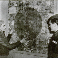
Aerial Map Untangles Traffic for Air Students
Item
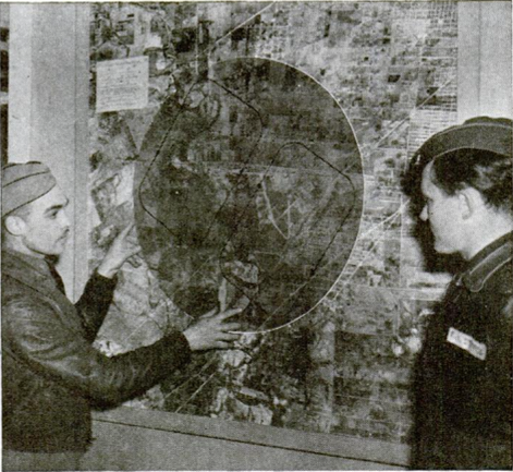
Traffic in the air above Kelly Field, a serious problem with 224 army air corps students making frequent training flights, has been safer since the “Trafficgram” went up on the wall at headquarters. It is a five-foot square aerial map of Kelly Field on which restricted and danger areas are marked. Pivoting about the mid-point of the airport is a glass disk on which are printed the rectangular courses the students must fly. Before taking off on a flight, the pilot turns the disk so that its index matches the wind direction, then reads on the map the exact traffic pattern, takeoff and landing lanes he must use.
- Title (Dublin Core)
- Aerial Map Untangles Traffic for Air Students
- Article Title and/or Image Caption (Dublin Core)
- Aerial Map Untangles Traffic for Air Students
- Language (Dublin Core)
- eng
- Temporal Coverage (Dublin Core)
- World War II
- Date Issued (Dublin Core)
- 1940-07
- Is Part Of (Dublin Core)
-
 Popular Mechanics, v. 74, n. 1, 1940
- pages (Bibliographic Ontology)
- 60
- Rights (Dublin Core)
- Public Domain (Google digitized)
- Source (Dublin Core)
- Google books
- References (Dublin Core)
- Kelly Field
- Archived by (Dublin Core)
- Enrico Saonara
- Alberto Bordignon (Supervisor)
- Spatial Coverage (Dublin Core)
- United States of America