-
Titolo
-
How to read aerial photos
-
Article Title and/or Image Caption
-
Title: How to read aerial photos
-
Subtitle: Reconnaissance shots yield telltale clues to trained eyes.
Try your own skill at it after reading this
-
extracted text
-
Ts a layman, many an aerial photograph
of a bombing objective resembles an ama- |
teur cameraman’s first attempt—and an un-
fortunate one at that. Looking at the same
reconnaissance picture, an Air Intelligence |
expert sees trenches, machine guns, houses, |
factories, railroads, and highways. |
Likewise, after bombers have done their
work, new photographs often fail to show
impressive evidence of destruction to the
layman's eyes. But the art of the trained
photo interpreter reveals telltale signs of
war plants knocked out of production, of
ruined airport runways, and of crippled rail
centers. |
An amateur can easily learn at least the |
ABC's of reading aerial photographs—a fas-
cinating detective game of making shrewd
deductions from simple clues. While some
of the methods that professionals use must
remain strict military secrets, enough can
be told here to make pictures from the air |
far more intelligible to a novice.
Any city, town, or countryside may pro-
vide landmarks to guide raiders, or may take
on military importance in a land campaign.
Suppose, therefore, we start with a strate-
gical background of familiar landscape fea- |
tures. Of course they will look strange from
the air, because we are accustomed to see-
ing them sideways and not from overhead.
To identify an object, the most important
aids include its shape, its lightness or dark-
ness, its shadow, and its size.
‘When a long, straight line crosses an
aerial photo, you need not look for locomo-
tives or cars to arrive at the conclusion that
it is a railway. If it does have curves, they
will be gradual, in accordance with stand-
ard railroading practice. Conversely, a series
of straight lines joined by sharp curves must
be a motor highway. Simple, isn't it?
It may take more imagination to decide
what to make of a chevron-shaped swath |
cut through a forest. A person experienced |
in looking at air views will recognize it as a |
clearing for a high-tension electric trans- |
mission line. Once you are in on the secret, |
the simplest geometry points to the tower
where the wires change direction. Because
of their way of marching across country
with little regard for topography, high- |
tension wires are easily recognized. |
Perhaps you will puzzle at first over one
of the most easily identified features of an |
air view—a pattern of black dots neatly ar-
ranged in rows and columns. It is an or-
chard, and the dots are the trees.
Natural features of a landscape readily
distinguish themselves from the regular pat-
terns of man-made objects. The wandering
course of a stream, for example, could hard-
ly be mistaken for anything else.
Gradations from white to black, called
tone or texture, tell a story of their own.
Roads, which reflect light well, show up in
light tones—the more heavily traveled, the
lighter. Plowed fields, too, are good reflec-
tors. Meadows look darker because of shad-
ows cast by the grass, just as plush looks
darker than satin of the same color. Woods,
heavily shadowed by trees, appear very dark.
Cultivated fields range through a variety of
intermediate tones of gray, from which an
expert can often determine just what crop
is being grown! A body of smooth water
may show up light or dark, according to the
angle of the sun, whose rays it reflects like
a mirror instead of scattering them like
loose soil.
Face a window or light, and hold an aerial
“photo with its shadows toward you. This
correct way of viewing it prevents hills from
being mistaken for hollows, and craters for
mounds. Besides giving an illusion of relief,
shadows also indicate shape and size. An
oblong object, half bright and half dark,
turns out to be a house with slanting roofs;
one roof slope faces the sun while the other
is in shadow. If you know the time of day
when a picture was taken, the height of a
building may be compared with its length
and width by noting the length of its shad-
ow on the ground.
In scaling the size of objects, comparisons
help. A truck on a road gives an idea of the
road’s width; and the size of a warehouse
may be estimated with respect to a dwelling.
Supplementing each other as they do,
these clues lead to further deductions. A
likely place to look for a bridge is a narrow
part of a river. A picture shows a well-trav-
eled highway leading to such a point. Closer
examination reveals the bridge itself —which
looks lighter than the water, and further
reveals itself by its size, shape, and shadow
on the stream. In the art of aerial photo
interpretation, as in chemistry and many
other fields, a skilled analyst has a pretty
good idea of what he is going to find before
he finds it.
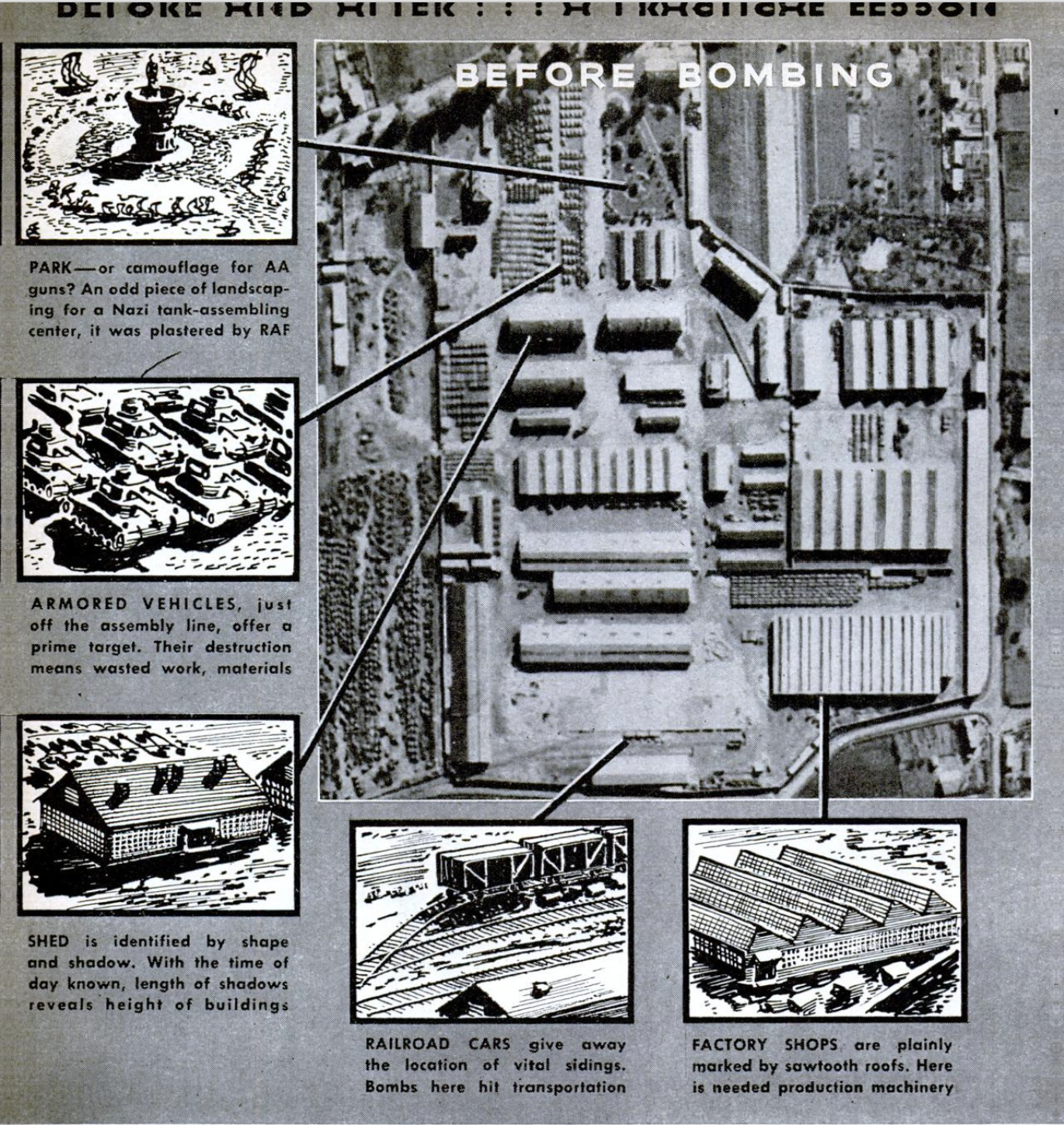
Superimposed upon ordinary terrain, mil-
itary works reveal themselves to the eye of
the flying camera. Trenches, reappearing in
the present war, stand out by virtue of their
zigzag pattern, or that of the earth dug out
to make them. ‘Foxholes” can usually be
picked out by their sharp outlines and deep
shadows. Wire entanglements show up as
broad lines or ribbons—accentuated, if new-
ly laid, by the tracks of working parties.
Similar tracks betray frequently visited
machine-gun positions. Grass trampled by
soldiers may be clearly distinguished from
other growth. Any disturbance of nature's
patterns is a sure sign of human activity.
Neither telephone posts, their shadows, nor
wires can usually be seen in reconnaissance
photos—but the earth removed to sink the
poles, and the trails left by construction
crews, make a series of small, regularly
spaced dots connected by a thin line. As
might be expected, a photo interpreter with
tactical training benefits by knowledge of
how he would dispose his own troops, guns,
and headquarters in a similar situation.
Permanent tar-
gets such as railroad yards, oil tanks, and
canal locks are virtually impossible to con-
ceal from aerial cameramen. Locations of
chemical works, arms factories, pipe lines,
and other objectives are known to industri-
alists all over the world, and picking them
out on reconnaissance photos offers little
difficulty. Even when they may be shifted
from place to place, the secret is hard to
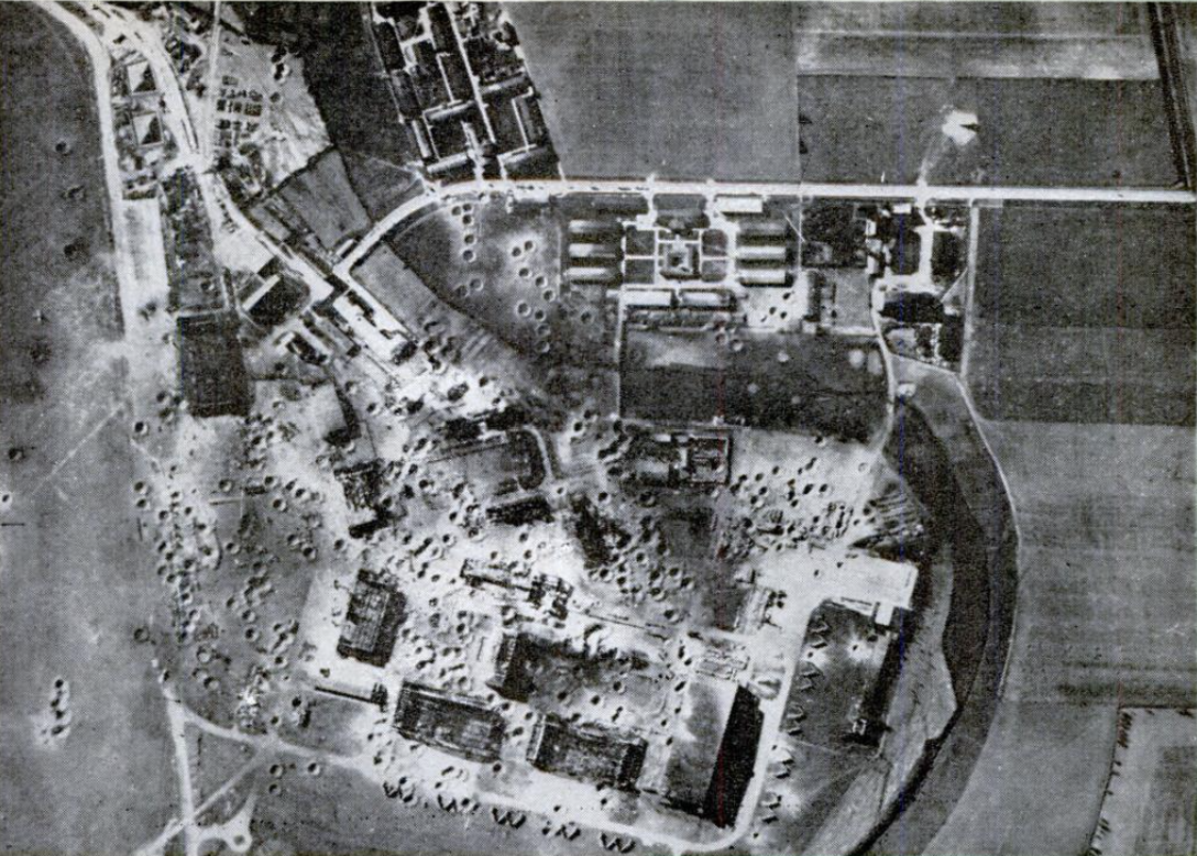
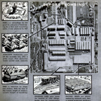
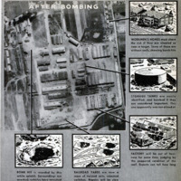
keep. From much-bombed Bremen, the
great Focke-Wulf airplane assembly plant
was moved to Marienburg in East Prussia,
farther than Allied bombers had ever pene-
trated into Germany. Just the day before
Reichsmarshal Hermann Goering was to
dedicate one of its new buildings, the U. S.
Army's Eighth Air Force spared him the
trouble by razing the whole Marienburg
plant to the ground. In this case, one of the
clearest air photos ever taken leaves no
doubt of the havoc wrought by precision
bombing.
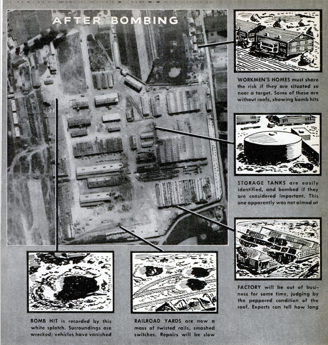
Less conspicuous clues often reveal the ex-
tent of destruction. A factory with a chunk
missing or with gaps in its roof probably
has suffered heavy damage from a near-by
hit and flying debris. Shapes like open
boxes are the shells of bombed-out buildings.
Tops of walls still standing appear white,
because the crumbled surfaces reflect sun-
light. A checkerboard pattern of bright
spots in the shadow of a wall indicates sun-
light streaming through the window spaces
of an unroofed structure. An indistinct,
blackened heap vaguely resembling the out-
line of a building signifies a ruin gutted by
fire. A white splotch, practically free of
shadows, shows where a bomb hit; and
signs of damage will radiate from it. If the
white scar is more or less oblong, a whole
building has been blasted from its site.
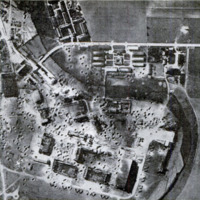
By comparing “before-and-after” pictures
of bombing, some of which are reproduced
here, a beginner quickly gets the idea. And
a professional photo interpreter, aided by
industrial technicians and statisticians, can
estimate with remarkable accuracy the
daily loss to the enemy in gasoline or ball
bearings; the percentage of his total re-
sources that this figure represents; and the
time that it will take to get any reparable
plants back into production.
Latest refinements of aerial photography
—notably, improved natural-color and relief
processes—come to his aid. New color film
permits views to be taken from planes speed-
ing faster, or in less favorable light, than
ever before. Their realistic hues unmask en-
emy attempts at camouflage that might go
unnoticed in black-and-white photography.
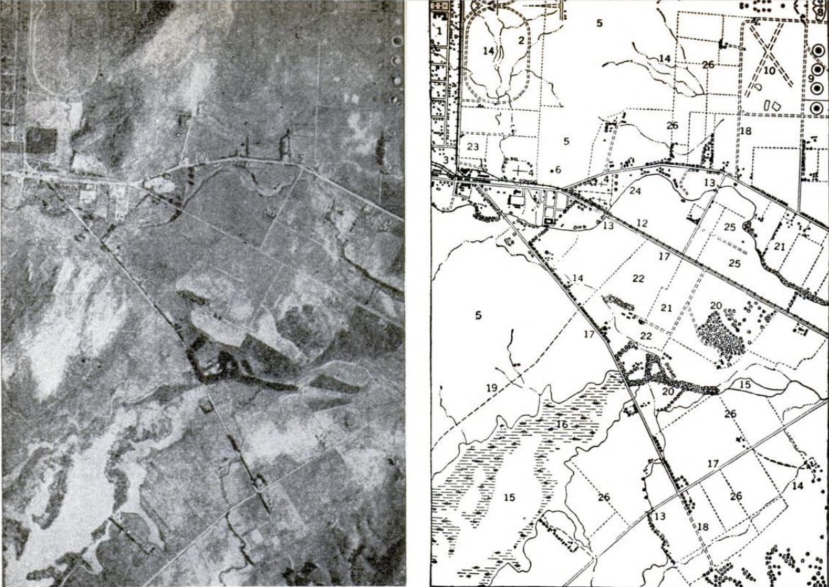
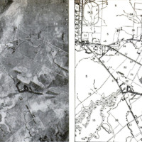
Relief views, which show objects in three
dimensions, take the flatness out of aerial
pictures. Here is an ordinary aerial photo-
graph of what looks like a smooth beach,
suitable for an invasion landing. A relief
picture shows, instead, a high cliff from
which a few gunners could mow down any
would-be invaders. Probably, signs of relief
in the flat picture—such details as stream
courses—would prevent a photo interpreter
from being misled, but a quick glance at
the other view saves time and effort. |
As for the man who makes the pictures,
it need not be supposed for a moment that
enemy forces look on complacently while
he photographs their installations. At all
costs, their object is to prevent him from
getting back to his base with the views.
Therefore, it is easy to imagine the frus-
trated wrath of a group of American air-
men in India. At regular intervals, a Japa-
nese airman, whom they nicknamed “Photo
Joe,” paid them visits. Between clicks of
his shutter, he radioed insults in perfect
English, confident that they had no plane
capable of reaching his high altitude in time
to catch him. Then the Yanks stripped a
P-40 of everything but guns and climbing
performance. Right on schedule, “Photo
Joe” reappeared with his taunts—just once
too often.
Fortune gave a different twist to a Euro-
pean incident when an American pilot, at
the completion of a photographic mission,
found an Axis fighter plane closing in on
either side of him. Just at the moment their
guns spat fire, he climbed sharply. While
his enemies shot each other down, he made
good his escape!
Freak engagements like this may be rare,
but daring exploits of flying cameramen
are legion. For there is military information
of inestimable value in the pictures they
bring back—if you know how to find it.
-
Autore secondario
-
Alden P. Armagnac (article writer)
-
Lingua
-
eng
-
Data di rilascio
-
1944-04
-
pagine
-
123-126, 199
-
Diritti
-
Public Domain (Google digitized)
-
Archived by
-
Lorenzo Chinellato
-
Marco Bortolami (editor)